


V-Alert: The All-In One Business Intelligence App
For Severe Weather And Disaster Preparedness, Response, Recovery, and Restoration
For Severe Weather And Disaster Preparedness, Response, Recovery, and Restoration
V-ALERT: State-of-the-Art Decision Support System for Professionals in:
V-ALERT is used by professionals in Restoration and Recovery, Property Management, Property Preservation, Facilities Management, Risk Management, and Operations Management to manage assets in the field, for resource mobilization, loss control, business continuity, emergency response, disaster response, preparedness, and real time alerts.
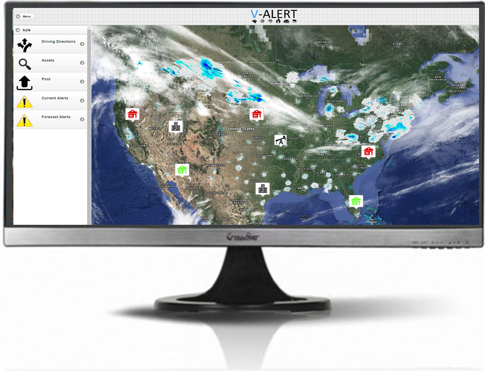
Continually monitor and track real-time weather and disaster events worldwide with V-ALERT. Affected areas are matched to your assets at their precise locations and automatic alerts are sent when there is potential for damage, or if other actions are required. No more searching multiple weather and disaster data sources and matching that data to your asset locations. Save hours of searching and mapping, insure data accuracy, and improve your overall effectiveness and efficiency with V-ALERT.
- Do more with fewer people
- Greatly improve management of employees and subcontractors
- Reduce the potential for millions of dollars in regulatory, EPA, state and local fines
- Avoid costly mistakes such as running rail lines through protected areas
- Provide asset reporting to sales and customer support

Efficiency
Generate work orders
Monitor properties
Manage claims
Reduce fraud
Customer Service
Respond to customers’ needs faster
Save your customers time and money
Increase Sales
Add new clients
Sell confidence
White label – It’s your product!
Show clients their assets are protected
V-ALERT: Severe Weather and Disaster Alerts
Zoom in and out of multiple views through the Command Center. Full search and filter capability provided. Authenticate users to see regional or client specific views and data.
Map Satellite View
Drone Imagery Overlaid
Upload Data from the Field
Create Visual Reports
Collaborate and Share Information in Real Time
Earth View and Navigation
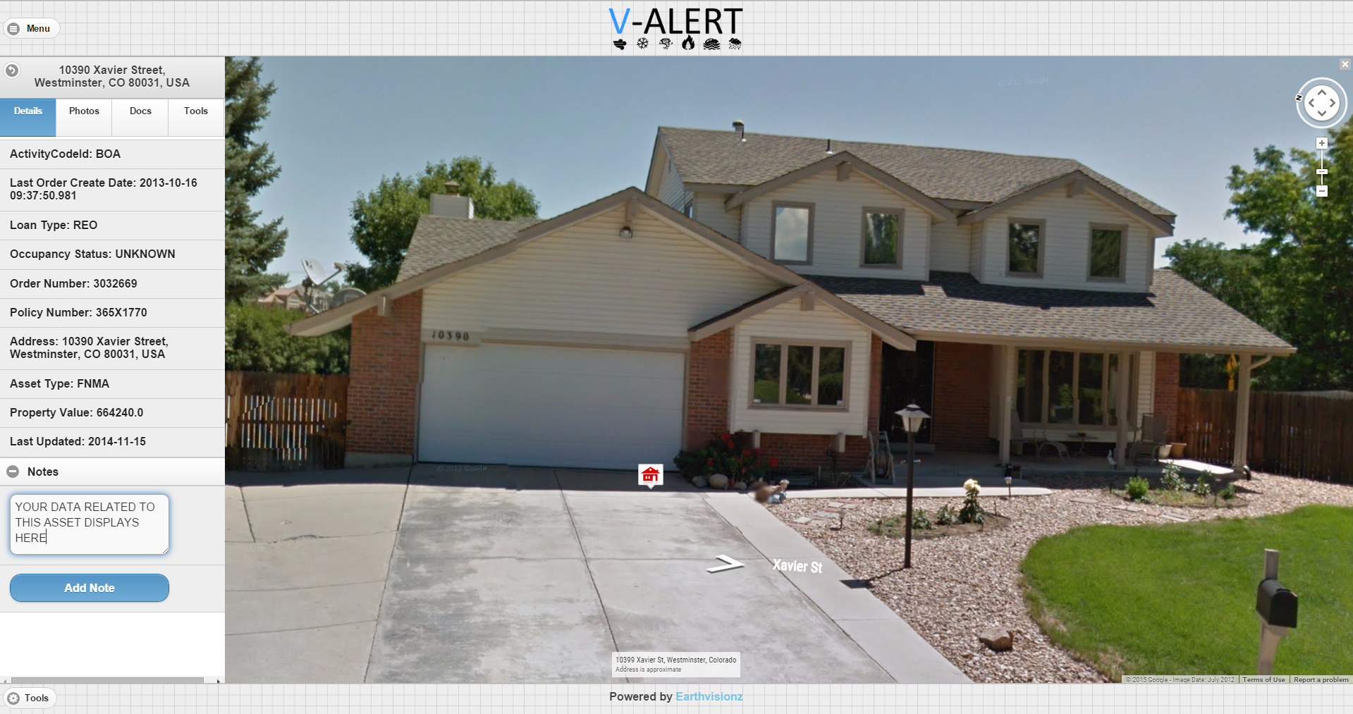
Street View
Near Real Time Imagery
Pre and Post Event
Archived Maps: Historical Analysis
360° Panoramas with Integrated Data
Photos Laid onto the Landscape
Live Cams 24/7 Monitoring
Overlay Heat Maps
Boundary Drawing Tools

V-ALERT ROI
- Get real-time severe weather and disaster alerts mapped directly to your assets
- Eliminate hours of searching weather feeds
- Eliminate hours of matching those feeds to your assets
- Insure asset data accuracy
- Improve your overall effectiveness and efficiency
- Increase sales and work orders
- Master V-Alert’s non-technical, intuitive interface with just a few hours of training
- No expensive workstation licenses required
- Manage users yourself: authenticate users to receive only the alerts you want them to see
- Turnkey solution with little IT intervention or support necessary
- Integrate with existing facilities and asset management systems or use as a stand-alone
- Customizable interface to maintain your company’s brand
Customizable
User interface
Intuitive icons
Add any data fields or live feeds
Efficient
Training provided
Turnkey application
Integrates with existing systems
Cost Effective
No workstation licenses required
Quick implementation
Increase workflow efficiency
Inexpensive geocoding
V-ALERT: ADD VIRTUALLY UNLIMITED DATA TO ALERTS
Increase the power of V-ALERT by adding data fields on any asset or group of assets.
Public and private data aggregated, organized and searchable
Regulatory data integration (EPA, State, Local)
Remote sensing data
Integrate many disparate data bases and attach to asset location
Empty those file cabinets! Scan and geo-tag paper records including spreadsheets, charts, graphs, maps, fusion tables
Interior data: Multimedia integration including 360° panoramic views to see inside structures
Map archives (ESRI, heat, government, floodplain, environmental contamination)
Live links to street cams and sensor networks (soil, gauging stations)

Structures
Homes/Commercial Buildings
Value
Type of Construction
HVAC
Facilities
Power Generators
Manufacturing
Tanks
Poles and Transmission Lines
Areas
Flood Plains
Cable Networks/Pipelines
Emergency Shelters
Roads, Highways and Bridges